FORT BELVOIR, Va. — To the untrained eye, U.S. Army radar-generated maps may look like a bird’s‑eye view of a city at night; however, these images contain useful intelligence, surveillance and reconnaissance information that reveal concealed objects by penetrating foliage, buildings and some terrain while overcoming camouflage, concealment and deception techniques.
 |
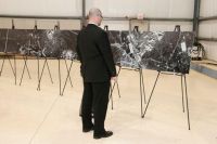
| Participants take a first-hand look at posters of TRACER generated images displayed at Fort Belvoir, Va., May 19. Photo credit U.S. Army Photo Click to enlarge |
These maps, which highlight boundaries not visible to traditional electronic sensors, are made possible by the U.S. Army’s Tactical Reconnaissance and Counter Concealment Enabled Radar, or TRACER. Developed by the Research, Development and Engineering Command’s communications and electronics center, TRACER is a mid-range, long wavelength synthetic aperture radar system that provides all-weather persistent surveillance.
Due to its decreased size, weight and power consumption compared to the predecessor Foliage Penetration Radar program, or FOPEN, TRACER operates on manned and unmanned platforms and produces images on-board in less than five minutes.
To introduce TRACER’s capabilities to Army and Department of Defense technology influencers and to emphasize the technology’s ability to penetrate more than just foliage, the Communications-Electronics Research, Development and Engineering Center hosted a VIP presentation May 19, at its Night Vision and Electronic Sensors Directorate facilities at Fort Belvoir, Va.
The predicted challenge of presenting TRACER to the Army at large is demystifying the notion that TRACER and FOPEN are only for foliage penetration.
“In some ways, we are a victim of our own success since FOPEN stands for foliage penetration but does more than just foliage penetration; it can reveal various areas of interest that may be camouflaged or obstructed and has applicability in multiple areas of operation,” said Dan Kuderna, chief, CERDEC Intelligence and Information Warfare Directorate Radar and Combat Identification Division.
The TRACER program began in April 2007, but FOPEN has been in the field since the late-90s and is the result of a joint Defense Advanced Research Project Agency, U.S. Air Force and Army Advanced Technology Development program. FOPEN was originally used to demonstrate low frequency radar’s ability to penetrate, but its proven success allowed it to be used for a variety of missions, said Kuderna.
As a follow-on to FOPEN, the TRACER system can be tailored to specific missions by providing a variety of SAR images including strip maps and spotlight and circle images.
Participants had a first-hand look at the TRACER payload integrated on a C‑12 platform and posters of TRACER-generated images.
“Overall, the presentation went very well,” Kuderna said. “VIPs got a positive impression, and there was serious interest in bringing the capability forward.”
This fall, TRACER will be tested on NASA’s unmanned Predator‑B (IKHANA), and later on Air Warrior.
Source:
RDECOM CERDEC Public Affairs Office
U.S. Department of Defense
Office of the Assistant Secretary of Defense (Public Affairs)

 von
von