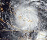
WASHINGTON, Aug. 25, 2011 — Military bases along the eastern seaboard are securing for the Category 3 winds and rain of Hurricane Irene, and the Defense Department is working closely with the Federal Emergency Management Agency as part of the U.S. government response, defense officials said today.
The Defense Department is providing air and ground transportation experts and defense coordinating officers to work with state, local and other federal agencies, process mission assignments and coordinate DOD resources in support of FEMA, the lead federal agency. DOD facilities in and near Irene’s forecast path are taking actions to alert, prepare and secure for the storm, officials said.
The storm was in the northwest Bahamas this morning, National Hurricane Center Director Bill Read said during a telephone briefing, moving over the Abaco Islands with sustained winds of 115 mph.
“The next area of concern as [Irene] exits the Bahamas is what the impact will be in North Carolina,” he said. “We have a hurricane watch up now for most of the North Carolina coast [and a] tropical storm watch through most of the South Carolina coast,” Read added.
The storm is expected to maintain major hurricane status — winds of at least 115 mph — as it approaches the coast of North Carolina the morning of Aug. 27, he said.
As the large storm passes through North Carolina, Read said, residents should expect very high winds and tropical-storm-force and hurricane-force winds over a large area.
With the National Hurricane Center’s next advisory at 5 p.m. EDT, Read said, “we’ll probably extend watches northward into the mid-Atlantic region.”
After it crosses North Carolina, he added, Irene is expected to continue moving toward the north-northeast, potentially bringing into play the Tidewater area of Virginia, the Delaware-Maryland-Virginia peninsula and the lower Chesapeake Bay, at a minimum.
“Any further deviation to the left could bring direct center impacts as far inland as the Washington-Baltimore area,” Read said. “After that, the rest of the eastern seaboard is well within the path of this storm.”
Irene will bring into play “all of the northeast corridor for heavy rains, high winds and coastal storm flooding,” he added.
Impacts on the morning of Aug. 28 are expected to be on the Delmarva peninsula and the New Jersey shore. That afternoon and into the following morning, the impacts will be in New England and New York, he said.
North and South Carolina, Virginia, Maryland, Delaware, New Jersey and New York have begun preparations. State officials have ordered mandatory evacuation for people in Hyde and Dare counties and on Ocracoke Island in North Carolina.
In North Carolina, Marine Corps Base Camp Lejeune, Marine Corps Air Station Cherry Point and Marine Corps Air Station New River have set Destructive Weather Condition 4, defense officials said, which means they project hurricane impact within 72 hours.
Navy squadrons in Virginia’s Hampton Roads area will hangar or evacuate aircraft tomorrow. Navy Vice Adm. Daniel P. Holloway, commander of the 2nd Fleet, today ordered all ships in Hampton Roads to be ready to get underway to avoid damage if the storm is expected to produce at least 50 knots of wind and a 5‑to-7-foot storm surge.
Navy Rear Adm. Mark S. Boensel, commander of Navy Region Mid-Atlantic, and Navy Rear Adm. Patrick J. Lorge, commandant of Naval District Washington, ordered emergency conditions of readiness for their areas of responsibility.
Defense officials say about 101,000 National Guard members are available if needed to governors of the affected East Coast states, territories and the District of Columbia.
In Puerto Rico, where Irene struck Aug. 21, members of the National Guard’s 190th Engineering Battalion have been activated to clear roads and debris, transport equipment, support communications, perform urban search and rescue, and support public safety.
U.S. Northern Command will support FEMA efforts along the East Coast and to Puerto Rico and the Virgin Islands with resources and experts.
FEMA has provided $8 million in funding to support the assistance, which includes military experts, air and ground transportation experts, emergency preparedness liaison officers and others.
Northcom officials have asked that the Joint Staff put 18 utility helicopters in a 24-hour prepare-to-deploy status to help with incident awareness and assessment. The command also requested that U.S. Transportation Command put a mobile public affairs detachment on 24-hour prepare-to-deploy order status.
FEMA Administrator Craig Fugate said his agency is pre-positioning supplies at military bases in North Carolina, Massachusetts and New Jersey. Supplies include heavy-duty generators, communications equipment, bottled water, shelf-stable meals, baby and infant supplies, tarps and durable medical goods to support shelter operations, Fugate said.
“Our role right now is focused on supporting governors as evacuations are being ordered, as we’ve seen already on the Outer Banks of North Carolina, and as we anticipate may be required further up the East Coast,” he said.
FEMA then will prepare for initial response to the aftermath of the hurricane by moving supplies into these areas to have them ready to go.
“We oftentimes focus on the coastal residents, but … this will not just be a coastal storm,” Fugate said. “We can see impacts well inland, both from winds that can cause widespread power outages as trees come down, especially due to the saturated soil, and also flooding.”
Source:
U.S. Department of Defense
Office of the Assistant Secretary of Defense (Public Affairs)

 von
von 